
Of the nine original lighthouses on the Oregon Coast, seven are open to the public and most are still active. If you time it right, you’ll get to go inside, take a tour, maybe go up the stairs to the watch room or even higher to the lantern room.
And there are two privately built lighthouses both of which are certified by the U.S. Coast Guard as official private aides to navigation. Neither is open to the public.
These 11 sentinels of the coast, revered by locals, sought by tourists, and seen far and wide in photos, each have a story to tell.
Tillamook Rock
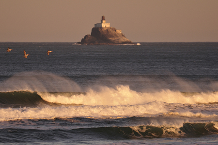
Built on a rocky island 1.2 miles offshore of Tillamook Head, Tillamook Rock Lighthouse represents an engineering and construction feat that overcame great obstacles. From 1880 when the lamp was lit until 1957 when it was decommissioned, “Terrible Tilly” served the maritime industry. Five keepers attended the lighthouse: four on duty at the lighthouse and one onshore on leave. No families lived at the lighthouse. Rotations were every three weeks for that’s when a boat returned the man on leave and brought provisions and mail. Because of the danger and isolation, these lighthouse keepers were paid more. Giant waves battered the lighthouse often shattering the protective glass around the light. During a storm in 1896, a rock weighing 135 pounds crashed through the roof and into the kitchen of the keeper’s quarters. After decommissioning, the lighthouse was abandoned for two decades. Under private ownership in 1980, the lighthouse was renovated and converted to a columbarium cemetery. Since 1994, the rocky islet has also been designated a federal wildlife refuge filled with nesting common murres and cormorants. The lighthouse can be seen from Ecola State Park and from Highway 101 south of Cannon Beach. It is not open to the public.
Cape Meares
Cape Meares Lighthouse is the star attraction at Cape Meares State Scenic Viewpoint. This piece of real estate is the most northerly cape of the Three Capes Scenic Loop and is also a national wildlife refuge because of the birds that nest on the cliffs. Features within the park include a picnic area and a trail to view offshore rocks, including Three Arch Rocks, and a trail to the unusual Octopus Tree. The lighthouse is open daily April through October from 11 a.m. to 4 p.m. and the trail to the lighthouse is wheelchair accessible. At 38 feet this is the shortest lighthouse on the Oregon Coast, but its lantern room holds the large first-order lens. The lens is in place but not in use. The lighthouse was deactivated in 1963 and the light replaced by a smaller but equally powerful automated electric light on a nearby steel tower. The Friends of Cape Meares helped save the lighthouse some years ago from being torn down and today maintain an Interpretive Gift Shop in what used to be a workroom. To schedule a tour of the lighthouse, contact the Friends of Cape Meares Lighthouse (503-842-2244) at least three weeks in advance between 11 a.m. and 3:15 p.m. from April through October.
Directions: Cape Meares is located on the Three Capes Scenic Loop north of the village of Oceanside and approximately 10 miles west of Tillamook. From Highway 101 in Tillamook follow signs to Cape Meares. Fee: No charge to see the park or lighthouse.
Yaquina Head
This is the second lighthouse built in the Newport area and at 93 feet high, it’s the tallest lighthouse on the Oregon Coast. The lighthouse is part of the Yaquina Head Outstanding Natural Area and is managed by the Bureau of Land Management (BLM). Besides the lighthouse at this natural area are tide pools, an impressive interpretive center, and nesting sea birds in the summer months. Gulls nest on the cliffs and common murres on the nearby offshore rocks. The murres can be packed in so tight, you hardly see the rock. The lighthouse is open for tours from 12 to 4 p.m. This is an active, working lighthouse with the original lens in place, but the light is now automated. Friends of Yaquina Lighthouses is a volunteer group that works toward restoration and preservation of both Newport lighthouses and the Interprative Center is open from 10am to 4 pm. Lighthouse lore contends that the lighthouse was intended for Cape Foulweather, but historical records show that the lighthouse was meant to be right where it is.
Directions: Yaquina Head is located about 3 miles north of Newport in the Agate Beach area. Turn at the Yaquina Head Outstanding Natural Area and continue about a mile to the lighthouse.
Fee: $7 per car to enter the Yaquina Head Outstanding Natura Area.
Yaquina Bay
On the southern end of Newport, just north of the Yaquina Bay Bridge, stands a lighthouse that is unique in several respects to any other Oregon lighthouse. After being built in 1871, it was decommissioned in 1874, giving it the distinction of having the shortest duration of active duty when it was originally built of any lighthouse on the coast. It’s the only one built of wood and has spacious living quarters attached to the lighthouse. In fact it looks like a two-story house with a light tower on the roof. And it’s the only one that also functions as a museum. Inside two sets of stairs lead to the watch room, but the lantern room is not open to the public. The basement, however, is open to the public and features an informative video. Since 1996, Yaquina Bay has been a working lighthouse with a steady white light from dusk to dawn. The Yaquina Lights, Inc, group helps preserve this lighthouse and members are there to answer questions. They also give private tours. The lighthouse is open every day except the winter holidays. The hours are from October to Memorial Day 12 to 4 p.m. and in the summer 11 a.m. to 5 p.m.
Directions: Turn right off Highway 101 regardless of which direction you are heading. Yaquina Bay Lighthouse is at the northern end of the bridge just to the west. Follow signs to Yaquina Bay State Recreation Site.
Fee: None, but donations are accepted. Private tours take place outside of normal operating hours and are $20 for one, $10 each for two to four. Call (541-574-3129) to arrange a tour.
Heceta Head
Heceta Head Lighthouse
Because it is so easy to pull over and see the postcard perfect view of Heceta Head with the lighthouse, assistant keepers house, and nearby offshore rocks, this scene has made Heceta Head the most photographed lighthouse on the Pacific Coast. It appears in numerous calendars and on note cards. This active 56-foot high lighthouse has a rotating beam that is still the most powerful on the Oregon Coast; this first-order lens shines 22 miles out to sea. The lighthouse needed major repairs a few years ago and was in danger of being deactivated, but the communities rallied and the lighthouse was renovated and is in better-than-ever working order. The assistant keepers’ house (Heceta House) is now the Heceta Lightstation Bed and Breakfast and serves a seven-course gourmet breakfast each morning you stay. Heceta House has been restored to its original splendor, and by day functions as an interpretive center. A long-time ghostly presence there is occasionally heard or seen. That doesn’t keep people away. The B&B welcomes guests year round, and guests are encouraged to view the lighthouse after dark. Standing at the base of the tower, watching the light go round has been described as “magical!” Nighttime tours are available to the public occasionally during the year. Daytime tours for both the B&B and the lighthouse take place Memorial Day through Labor Day from Thursday through Sunday. Call the B&B for hours (541-547-3696). Here’s a piece of trivia: This lighthouse once had a second house, the keeper’s house, that was torn down many years ago, and the wood was recycled in a building in Mapleton that now houses Alpha Bits cafe and gift shop.
Directions: Off Highway 101 about 12 miles north of Florence. Turn at Heceta Head Lighthouse State Scenic Viewpoint and park at Devil’s Elbow Beach, walk up a trail to the lighthouse, and then continue on about a quarter mile to the lighthouse.
Fee: Day-use fee is $3 per vehicle.
Umpqua River
Whale observation Deck at the Umpqua River Lighthouse
Although slightly taller at 65 feet, Umpqua River Lighthouse is almost identical to Heceta Head for they were built from the same plans. This was not the first lighthouse to be built on the Umpqua River, the first one was the very first one built on the Oregon Coast in 1857 and the shifting sands toppled it after only seven years. The current lighthouse was built on the bluffs overlooking the beach and was illuminated in 1994 with a first-order lens that has 6 red bull’s-eye lenses among the 24 bull’s-eye lenses. This creates alternating white and red beams that are mesmerizing to watch, especially if there is any mist in the air. The lighthouse is situated near other sites worth seeing too. Across the road is a whale-watch platform, about 200 yards away is the Coastal Visitors Center with its historical exhibits, and next door is its namesake state park—Umpqua Lighthouse State Park. The lighthouse is open for tours May through September from 10 a.m. to 4 p.m. For winter tours, call for an appointment (541-271-4631).
Directions: Umpqua River Lighthouse is located on Umpqua Lighthouse Loop out of Winchester Bay. About a mile out of Winchester Bay, watch for signs for when to turn uphill to the lighthouse, state park, and on to Highway 101.
Fee: In the past, there as been a $1 fee with no charge for children under 12.
Cape Arago
Located just south of the entrance to Coos Bay, the tremendous shipping traffic of lumber out of Coos Bay and North Bend required the establishment of a light, especially after the Umpqua River Lighthouse collapsed in 1861. The first Cape Arago Lighthouse was built in 1866 and then a second was built in 1908. This is the third lighthouse to occupy the same location. The first two fell victim to weather and erosion. The third was built of reinforced concrete in 1934, and today the U.S. Coast Guard maintains the 44-foot lighthouse. Before and shortly after the turn of the 20th century, there was a lifesaving station on one side of Lighthouse Island and the light keepers often alerted the surf men when ships were in trouble. This way many lives were saved. Today the walkway out to Lighthouse Island (a.k.a. Gregory Point) is in rickety condition and condemned for public use. This lighthouse originally had a fourth-order lens (first order is the largest). A modern beacon replaced it in 1993, when the lighthouse was renovated by the Coast Guard, and automated in 1996. This is the most difficult lighthouse to find. But good views are possible from a turnout about a half to three quarter mile south of Sunset Bay State Park and from the hiking trail between Sunset Bay and Shore Acres state parks.
Directions: Cape Arago Lighthouse is located about 4 miles south of Charleston between Sunset Bay and Shore Acres state parks. Follow signs to the state parks.
Coquille River
Completed in 1896, the Coquille River Lighthouse with its 40-foot tower was built on a rocky islet and reached by a footbridge—like Cape Arago today. But time has changed the landscape. Now the north jetty has hooked up with the land on which the lighthouse stands. The lighthouse design was unique with its cylindrical tower attached to the east side of an elongated, octagonal room, which housed the fog signal equipment and had a large trumpet protruding from its western wall. That trumpet is no longer there. The lighthouse was active until 1939 when the Coast Guard placed a smaller light and fog signal on the river’s south jetty. Then the lighthouse was abandoned. When Bullards Beach State Park was created in 1964, the grounds of the light station were included. Restored in the late 1970s by park personnel working with the Corps of Engineers, the renovated lighthouse opened to the public as an interpretive center in 1979. Since then, it’s been claimed as a symbol by nearby Bandon and is commonly referred to now as Bandon Light. As part of Bandon’s centennial celebration in 1991, a solar-powered light was placed in the tower. And the lighthouse is further illuminated in December, when it’s outlined in lights. The lighthouse is staffed from May through October with park volunteers who interpret the history of the area and lead tours to the lantern room.
Directions: Within Bullards Beach State Park. Turn at the state park sign about 2 miles north of Bandon. Follow signs to the lighthouse.
Fee: Day-use fee of $3 per vehicle.
Cape Blanco
Towering above the westernmost point in Oregon, Cape Blanco Lighthouse sits 245 feet above the ocean with a 59-foot tower. It has the highest focal plane above the sea of any other lighthouse in Oregon and is the oldest continuously operating light. Built in 1870, the lighthouse originally had a first-order non-rotating lens. A second-order rotating lens was installed about 1936. Two of Cape Blanco’s most distinguished keepers were James Langlois and James Hughes. (Hughes was a son of the Hughes family whose 2000-acre ranch bordered the lightstation property.) They both served their entire careers at Cape Blanco—Langlois 42 years and Hughes 38 years. Those are amazing records in any time period, but when they were there, the South Coast was quite isolated. It wasn’t until the 1930s when Highway 101 was a reality that there was a decent road to the area. It still takes some doing to get to the lighthouse. It’s located 5 miles off Highway 101. When visiting plan to stop at historic Hughes House also a part of Cape Blanco State Park. Both the lighthouse and house have tours on the same schedule: April through October, Tuesday through Sunday, 10 a.m. to 3:30 p.m.
Directions: The turnoff to Cape Blanco State Park is about a mile south of the Sixes River and 4-1/2 miles north of Port Orford. Follow the road a few miles to Hughes House and continue on to the Lighthouse a couple miles farther.
Fee: Day-use fee of $3 per vehicle.
Cleft of the Rock
Nestled in the northern shadows of Cape Perpetua on a bluff overlooking the ocean sits a neat A-frame structure attached to a lighthouse. It is the home of Jim Gibbs, former U.S. Coast Guardsman, lighthouse keeper, and noted author and historian. Gibbs, author of 21 maritime books, is considered an authority on Pacific Coast lighthouses. Gibbs built his lighthouse/home 29 years ago. The home’s entrance is the rotunda of the lighthouse, which is filled with photographs and artifacts of Northwest lighthouses. Cleft of the Rock was planned from the beginning to be a combined lighthouse and home. It was built in 1976 and based on the plans for a Canadian lighthouse, Vancouver Island’s Fiddle Reef Light. Gibbs’ lantern room houses the lens once used at the Solander Island Lighthouse, also in British Columbia. In 1979 the Coast Guard designated Cleft of the Rock as an official private aid to navigation. The light can be seen more than 16 miles out to sea.
Directions: Cleft of the Rock is closed to the public, but can be viewed from Milepost 166 on Highway 101, 1-1/2 miles south of Yachats.
Pelican Bay
Pelican Bay Lighthouse stands watch on a bluff 141 feet above the Chetco River. It’s Oregon’s newest light and the state’s second residence to be designated a private aid to navigation by the Coast Guard. Bill and JoAnn Cady each grew up by the sea and Bill’s father was a light keeper. In his father’s 37-year career, Bill lived at lightstations in California at Cape Mendocino, Point Loma, and Trinidad in Northern California. The Cady’s built their lighthouse/home but ended up moving the lighthouse portion to a different location and rebuilding the house part. The original location had new development restrict their view. After settling into their second location, they began to seriously think about installing a working light. After much research, they installed a light with a range of 11 nautical miles that goes on at dusk and off at dawn. The Coast Guard commissioned it officially on July 4, 1999.
Directions: Pelican Bay is not open to the public. From Highway 101 from the north, turn right at the south end of the Chetco River Bridge onto Lower Harbor Road. From Highway 191 from the south, turn left at the first signal north of California/Oregon stateline (Benham Road), and travel to the boat basin.